- Professional Development
- Medicine & Nursing
- Arts & Crafts
- Health & Wellbeing
- Personal Development
80 Urban Planning courses
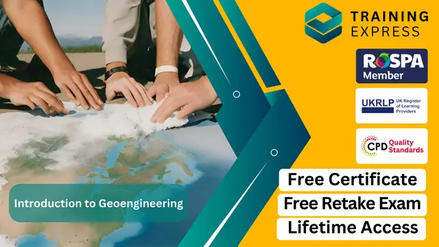
Diploma in Environmental Awareness Training - Level 2 (QLS Endorsed)
By Kingston Open College
QLS Endorsed + CPD QS Accredited - Dual Certification | Instant Access | 24/7 Tutor Support

Geoengineering is a rapidly emerging field that focuses on manipulating the Earth’s environment to combat climate change. This course offers a deep dive into the science and techniques used in geoengineering, with a clear focus on methods designed to reduce global warming and other environmental issues. Students will explore various geoengineering concepts, from carbon capture and storage to solar radiation management, while evaluating their potential impact on the planet. The course is designed to equip learners with an understanding of the technological, ethical, and societal implications of these approaches. By the end of the course, learners will have a solid foundation in the core principles of geoengineering, enabling them to critically assess the possible solutions it offers for mitigating climate change. The course delves into both the technical and policy aspects, giving learners a well-rounded perspective on this cutting-edge field. It will also explore current research and debates surrounding geoengineering, providing an engaging experience that blends science with social responsibility. Whether you're looking to pursue a career in environmental sciences or simply have an interest in climate change solutions, this course offers a clear and accessible introduction to the field of geoengineering. Key Features CPD Accredited FREE PDF + Hardcopy certificate Fully online, interactive course Self-paced learning and laptop, tablet and smartphone-friendly 24/7 Learning Assistance Discounts on bulk purchases Course Curriculum Module 01: Earth Processes and Soil Basics Module 02: Soil Classification and Behaviour Module 03: Geotechnical Properties of Soils Module 04: Ground Improvement Techniques Module 05: Geoenvironmental Engineering Module 06: Geotechnical Site Investigation Learning Outcomes: Analyse Earth processes influencing soil behaviour for effective engineering solutions. Demonstrate proficiency in classifying soils to inform geotechnical decisions. Evaluate geotechnical properties of soils crucial for engineering applications. Apply ground improvement techniques for enhanced stability and performance. Assess the intersection of geotechnology and environmental considerations. Conduct geotechnical site investigations with precision and interpretive skills. Accreditation This course is CPD Quality Standards (CPD QS) accredited, providing you with up-to-date skills and knowledge and helping you to become more competent and effective in your chosen field. Certificate After completing this course, you will get a FREE Digital Certificate from Training Express. CPD 10 CPD hours / points Accredited by CPD Quality Standards Who is this course for? Civil engineers aspiring to specialise in geoengineering. Environmental scientists seeking a geotechnical perspective. Construction professionals enhancing their soil engineering expertise. Graduates pursuing a career in geotechnical engineering. Project managers involved in infrastructure development. Urban planners interested in sustainable geotechnical solutions. Soil scientists aiming to apply their knowledge in practical settings. Engineering enthusiasts fascinated by the complexities of soil dynamics. Career path Geotechnical Engineer Environmental Consultant Construction Project Manager Civil Engineering Consultant Urban Planning Officer Soil Scientist Certificates Digital certificate Digital certificate - Included Once you've successfully completed your course, you will immediately be sent a FREE digital certificate. Hard copy certificate Hard copy certificate - Included Also, you can have your FREE printed certificate delivered by post (shipping cost £3.99 in the UK). For all international addresses outside of the United Kingdom, the delivery fee for a hardcopy certificate will be only £10. Our certifications have no expiry dates, although we do recommend that you renew them every 12 months.
Sale Ends Today!! Geotechnical Engineering Admission Gifts FREE PDF & Hard Copy Certificate| PDF Transcripts| FREE Student ID| Assessment| Lifetime Access| Enrolment Letter Do you ever wonder what lies beneath the towering skyscrapers or the vast network of roads you traverse every day? Ground instability in the UK costs over £3 billion annually, while the construction industry contributes over £112 billion to the economy and employs 2.9 million people, highlighting the crucial role of Geotechnical Engineering in ensuring safe and sustainable infrastructure. This Geotechnical Engineering bundle delves into the fascinating world of Geotechnical Engineering, equipping you with the knowledge and skills to assess, analyse, and manage the very foundation of our infrastructure. With our Geotechnical Engineering exclusive bundle, you will get a PDF Certificate, PDF Transcript and Digital Student ID Card (worth £50) Absolutely FREE. Courses are Included in This Geotechnical Engineering Bundle: Course 01: Advanced Diploma in Geology at QLS Level 7 Course 02: Structural Geology: Geological Landscape of the Earth Course 03: Geospatial Technology: GIS and Remote Sensing Course 04 The Basics of ArcGIS for Hydrology Course 05: Spatial Analysis in ArcGIS Course 06: Remote Sensing in ArcGIS Course 07: QGIS Cartography Course 08: Applied Statistics Course 09: MATLAB Simulink for Electrical Power Engineering Course 10: Autocad Design Course 11: Forensic Anthropology Course 12: Meteorology Course 13: Carbon Literacy Knowledge Course 14: Petrolium Engineering Course 15: Oil and Gas Management Course 16: Diploma in Water Chemistry Course 17: Agricultural Science Course 18: Environment Management Course 19: Environmental Law Course 20: Forestry Course 21: Gemology Course 22: Construction Management Course 23: Land Management Course 24: Building Surveying Course 25: Architectural Studies 5 Amazing Career Courses to Help You Level Up Your Skills: Course 26: Effective Communication Skills Course 27: Delegation Skills Training Course 28: Time Management Course 29: Leadership Skills Training Course 30: Decision Making and Critical Thinking This Geotechnical Engineering bundle covers advanced geology, environmental law, ArcGIS, hydrology, remote sensing, forensic anthropology, meteorology, carbon literacy, land management, environmental health, resource management, oil, gas, water chemistry, agricultural science, and architectural studies, providing a comprehensive understanding of geotechnical engineering, land management, and environmental health. Enhance your career prospects, boost your understanding of Geotechnical Engineering challenges, and contribute to building a stronger, more resilient future. Take the first step and enrol today in our Geotechnical Engineering bundle! Learning Outcomes of Geotechnical Engineering Bundle Master advanced geology principles and their application in construction. Gain proficiency in ArcGIS for effective spatial analysis in geotechnical engineering. Understand remote sensing techniques for environmental assessment. Learn the basics of hydrology and its application in engineering. Acquire knowledge in environmental law and land management. Develop skills in resource management, including oil and gas. Why Choose Our Geotechnical Engineering Bundle ? FREE Geotechnical Engineering certificate accredited Get a free student ID card with Geotechnical Engineering Training Get instant access to this Geotechnical Engineering course. Learn Geotechnical Engineering from anywhere in the world The Geotechnical Engineering is affordable and simple to understand The Geotechnical Engineering is an entirely online, interactive lesson with voiceover audio Lifetime access to the Geotechnical Engineering course materials The Geotechnical Engineering comes with 24/7 tutor support Start your learning journey straight away! The "Geotechnical Engineering Bundle" provides an extensive array of courses that equip learners with cutting-edge skills and knowledge in the field of geotechnical engineering and related disciplines. By diving into advanced Geology and Structural Analyses of the Earth's Landscape, participants will gain a robust understanding of geological processes and structures, enhancing their ability to tackle complex geotechnical challenges. Furthermore, the integration of GIS and Remote Sensing into the curriculum allows for the application of geospatial technologies, optimising Data Analysis and Decision-Making in critical scenarios. This comprehensive bundle also includes specialised training in ArcGIS tools tailored for Hydrology, Spatial Analysis, and Remote Sensing applications. Such skills are invaluable in today's technology-driven work environments, where precision and efficiency in data handling and interpretation are essential. Learners will emerge with the capability to implement these tools effectively, leading to more informed and accurate project outcomes. Moreover, this diploma offers learners the opportunity to acquire skills that are highly valued in the field of Geotechnical Engineering. With this Certification, graduates are better positioned to pursue career advancement and higher responsibilities within the Geotechnical Engineering setting. The skills and knowledge gained from this course will enable learners to make meaningful contributions to Geotechnical Engineering related fields impacting their Geotechnical Engineering experiences and long-term development. Course Curriculum Course 01: Advanced Diploma in Geology at QLS Level 7 Module 01: Basic Introduction Module 02: Tectonics Module 03: Geologic Time Module 04: Geologic Materials Module 05: Volcano Module 06: Earthquake And Earth's Structure (Core) Module 07: The Earth Atmosphere Module 08: Natural Resources Module 09: Earth's Internal Structure Course 02: Structural Geology: Geological Landscape of the Earth Module 01: Introduction Module 02: Solar System Module 03: Geologic Time Module 04: Inside Earth Module 05: Plate Tectonics Module 06: Weathering Module 07: Deserts & Winds Module 08: Minerals Module 09: Sedimentary Rocks Module 10: Metamorphic Rocks Module 11: Igneous Rock Module 12: Deformation Module 13: Volcanoes Module 14: Mass Wasting Module 15: Surface Water Course 03: Geospatial Technology: GIS and Remote Sensing Module 01: Introduction To Geospatial Technology Module 02: Geographic Information Systems (GIS) Basics Module 03: Spatial Data Management Module 04: Spatial Analysis Techniques Module 05: Remote Sensing And Imagery Module 06: Web-Based Mapping And Visualisation Module 07: Geospatial Programming And Automation Module 08: GIS Applications And Real-World Projects =========>>>>> And 27 More Courses <<<<<========= How will I get my Certificate? After successfully completing the course, you will be able to order your Certificates as proof of your achievement. PDF Certificate: Free (Previously it was £12.99*30 = £390) CPD Hard Copy Certificate: Free (For The First Course: Previously it was £29.99) CPD 300 CPD hours / points Accredited by CPD Quality Standards Who is this course for? This Geotechnical Engineering bundle is suitable for everyone. Aspiring geotechnical engineers. GIS specialists. Environmental consultants. Construction project managers. Urban planning professionals. Hydrology and forestry experts. Requirements You will not need any prior background or expertise in this Geotechnical Engineering bundle. Career path This Geotechnical Engineering bundle will allow you to kickstart or take your career in the related sector to the next stage such as: Geotechnical Engineer: $65,000 - $100,000 GIS Analyst: $50,000 - $75,000 Remote Sensing Specialist: $60,000 - $90,000 Environmental Consultant: $50,000 - $80,000 Construction Project Manager: $70,000 - $110,000 Hydrologist: $60,000 - $90,000 Certificates CPD Accredited Digital Certificate Digital certificate - Included CPD Accredited e-Certificate - Free Enrolment Letter - Free Student ID Card - Free CPD Accredited Hard Copy Certificate Hard copy certificate - Included If you are an international student, then you have to pay an additional 10 GBP for each certificate as an international delivery charge.
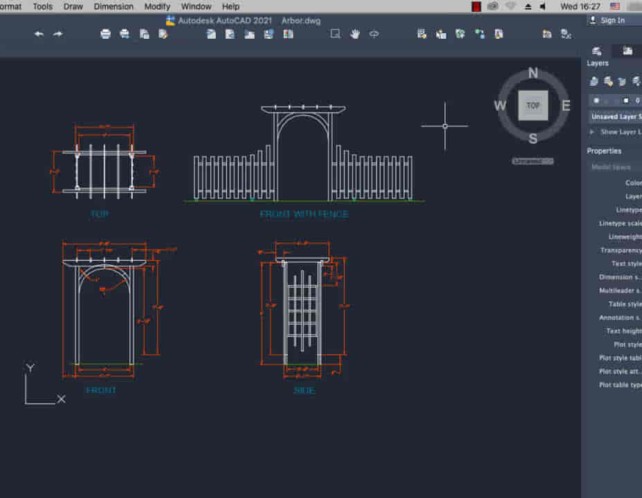
Bespoke AutoCAD Mac Basic-Intermediate Course
By ATL Autocad Training London
Why Learn Bespoke AutoCAD Mac Basic-Intermediate Course? Learn AutoCAD using your projects and learn how to use powerful tools and techniques for drawing, dimensioning, and printing 2D drawings with our Intermediate AutoCAD course. Check our Website How long is the training? 10 hours, Choose and split 10 hrs Mon to Sat 9 am to 7 pm. Book online or call 02077202581 or 07970325184. Method? 1-on-1, available in both in-person and Live Online. Course Topics Include: Building Fundamental Shapes Working with Lines, Arcs, and Polylines Utilizing Grip Tools Precision Object Alignment Data Management and Backups Exploring File Formats Ensuring Disaster Recovery Mastering Object Creation Handling Measurement Units Dynamic Input Techniques Inquiring Commands and Measurement Tools Effective Object Viewing Navigating Zoom and Pan Object Manipulation Strategies Object Selection Methods Swift Object Management Object Transformation Techniques Scaling and Altering Objects Trim, Extend, and Offset Functions Creating Geometric Variations Object Joining and Editing Corner Filleting and Chamfering Stretching Objects Organizing Your Drawings Layer Management Customizing Object Properties Applying Linetypes Layout Design and Setup Efficient Page Configurations Scaling Drawing Views Adding Annotations Multiline and Single-Line Text Creation Text Styling and Editing Dimensioning Concepts Customizing Dimension Styles Dimension Editing Implementing Multileaders Object Hatching Hatching Editing Reusable Content Management Blocks and Symbols Tool Palette Usage Working with Groups Model Space and Paper Space Understanding Layout Creation and Viewports Viewport Scaling Plotting and PDF Output Managing Multiple Sheet Drawings Utilizing Plotstyles Crafting Custom Drawing Templates Download AutoCAD Mac https://www.autodesk.co.uk After completing the AutoCAD for Mac course, learners can expect the following learning outcomes: Proficiency in AutoCAD: Participants will acquire the skills and knowledge needed to confidently use AutoCAD for Mac, including creating and editing drawings, managing objects, and applying precision techniques. Effective Design Skills: They will gain the ability to produce accurate 2D drawings, making them valuable assets in design-related professions. Jobs that individuals can pursue after completing this course include: Draftsperson: Working in architectural, engineering, or construction firms to create technical drawings and plans. CAD Technician: Assisting in the development of designs for various projects, such as product design or urban planning. Interior Designer: Using AutoCAD for space planning and layout design in the interior design industry. Architectural Designer: Collaborating on architectural projects, including creating floor plans and elevations. Mechanical Designer: Participating in the design and development of mechanical components and systems. Civil Engineering Technician: Supporting civil engineers in designing infrastructure projects, such as roads and bridges. Electrical or Electronics Designer: Assisting in the creation of electrical schematics and electronic circuit diagrams. Landscape Designer: Planning and visualizing outdoor spaces, gardens, and landscapes. Completing this AutoCAD course opens doors to various industries where precise and detailed 2D drawing skills are highly valued. The AutoCAD Mac Bespoke 1 on 1 Basics to Intermediate Level Training Course provides participants with a comprehensive skill set, enabling them to attain proficiency in using AutoCAD Mac. This course covers a wide range of functionalities and caters to individuals at all skill levels, whether they are beginners or experienced users. Participants will begin by learning fundamental features such as drawing, editing, annotations, and dimensioning. As they progress, they will delve into more advanced topics like object manipulation, customizing workspaces, and streamlining workflows. Key Benefits of the Course: Mastery of Mac-AutoCAD: Acquire expertise in both essential and advanced techniques for creating precise 2D drawings. Enhanced Productivity: Increase efficiency by implementing time-saving tips and optimizing your work processes. Versatile Design Abilities: Develop the skills to undertake diverse projects in fields such as architecture, engineering, and more. Industry-Relevant Competencies: Elevate your career prospects across various industries by gaining in-demand AutoCAD skills. Access to Recorded Lessons: Review and reinforce your learning at your convenience with access to recorded lesson sessions. Ongoing Email Support: Receive continuous assistance and guidance via email even after completing the course. Enroll today to benefit from interactive learning experiences guided by experienced instructors. Choose between flexible in-person or online sessions, gain access to lesson recordings, and enjoy a lifetime of email support. Tailored Guidance: Get personalized coaching and instruction tailored to your unique learning needs and objectives. Convenient Scheduling: Choose from flexible training slots available Monday to Saturday from 9 am to 7 pm, accommodating your busy schedule. Versatile Learning Options: Select between in-person training at our location, conveniently situated just 5 minutes away from Oval Tube Station, or participate in live online sessions from anywhere. Engaging Interactions: Participate in interactive sessions designed for questions, discussions, and problem-solving, creating an immersive learning experience. Effective Progression: Accelerate your learning with focused guidance, allowing you to advance at your own pace while mastering the material. Tailored Curriculum: Customize the course content to align with your prior knowledge and specific areas of interest, ensuring a relevant and engaging learning experience. Real-Time Guidance: Receive immediate feedback from the instructor, enhancing your comprehension and skill development. Comprehensive Support: Enjoy ongoing assistance and clarification opportunities through email or additional sessions beyond the course for an in-depth learning experience.
Step into the fascinating world of 'Geospatial Technology, Remote Sensing, and Web Mapping,' where learning becomes an exciting voyage. This course is not your typical academic roadmap; it's a dynamic adventure that plunges you into the intricate dance between technology and geography. From untangling the threads of Geographic Information Systems (GIS) Basics to harnessing the capabilities of Remote Sensing, each module unfolds as a thrilling chapter in your expedition toward spatial expertise. Envision not just absorbing knowledge but actively shaping the landscape of the future. This course isn't a lecture; it's an invitation to embark on a daring escapade, challenging you to lead the charge in spatial exploration. Join us and redefine the boundaries where data and vision collide. In this educational escapade, modules don't unfold; they reveal themselves like captivating tales, guiding you through the technological evolution. Traverse the landscapes of spatial data management, waltz through the artistry of web-based mapping, and immerse yourself in the wizardry of geospatial programming. This isn't just about accumulating information; it's about emerging as a pioneer, armed with skills that defy convention. Enlist now to navigate a future where every data point holds the promise of revelation, and every map transforms into a canvas of possibilities. Learning Outcomes Develop an in-depth understanding of Geospatial Technology, bridging the gap between theory and hands-on applications in real-world projects. Master the essentials of Geographic Information Systems (GIS), skillfully utilizing spatial data for insightful analysis and decision-making. Cultivate expertise in spatial data management, ensuring the efficient organization of geospatial information. Explore advanced spatial analysis techniques, extracting meaningful insights from intricate geographic datasets. Unleash the potential of Remote Sensing and Imagery, gaining heightened awareness of Earth's surface and environmental dynamics. Why choose this Geospatial Technology, Remote Sensing and Web Mapping course? Unlimited access to the course for a lifetime. Opportunity to earn a certificate accredited by the CPD Quality Standards and CIQ after completing this course. Structured lesson planning in line with industry standards. Immerse yourself in innovative and captivating course materials and activities. Assessments designed to evaluate advanced cognitive abilities and skill proficiency. Flexibility to complete the Course at your own pace, on your own schedule. Receive full tutor support throughout the week, from Monday to Friday, to enhance your learning experience. Unlock career resources for CV improvement, interview readiness, and job success. Who is this Geospatial Technology, Remote Sensing and Web Mapping course for? Tech enthusiasts eager to unravel the fusion of geography and cutting-edge technologies. Visionaries in environmental science, urban planning, or data analytics. GIS professionals hungry for skill enhancement and the latest industry insights. Aspiring geospatial programmers, ready to script the future. Urban planners and policymakers keen on integrating geospatial tools for strategic decision-making. Career path Geospatial Visionary: £25,000 - £35,000 per annum GIS Alchemist: £30,000 - £40,000 per annum Remote Sensing Maestro: £35,000 - £45,000 per annum Web Mapping Virtuoso: £28,000 - £38,000 per annum Geospatial Code Wizard: £26,000 - £36,000 per annum GIS Applications Guru: £30,000 - £40,000 per annum Prerequisites This Geospatial Technology, Remote Sensing and Web Mapping does not require you to have any prior qualifications or experience. You can just enrol and start learning.This Geospatial Technology, Remote Sensing and Web Mapping was made by professionals and it is compatible with all PC's, Mac's, tablets and smartphones. You will be able to access the course from anywhere at any time as long as you have a good enough internet connection. Certification After studying the course materials, there will be a written assignment test which you can take at the end of the course. After successfully passing the test you will be able to claim the pdf certificate for £4.99 Original Hard Copy certificates need to be ordered at an additional cost of £8. Course Curriculum Module 01: Introduction to Geospatial Technology Introduction to Geospatial Technology 00:18:00 Module 02: Geographic Information Systems (GIS) Basics Geographic Information Systems (GIS) Basics 00:22:00 Module 03: Spatial Data Management Spatial Data Management 00:20:00 Module 04: Spatial Analysis Techniques Spatial Analysis Techniques 00:16:00 Module 05: Remote Sensing and Imagery Remote Sensing and Imagery 00:19:00 Module 06: Web-Based Mapping and Visualisation Web-Based Mapping and Visualisation 00:19:00 Module 07: Geospatial Programming and Automation Geospatial Programming and Automation 00:17:00 Module 08: GIS Applications and Real-World Projects GIS Applications and Real-World Projects 00:15:00


Register on the Town Planning today and build the experience, skills and knowledge you need to enhance your professional development and work towards your dream job. Study this course through online learning and take the first steps towards a long-term career. The course consists of a number of easy to digest, in-depth modules, designed to provide you with a detailed, expert level of knowledge. Learn through a mixture of instructional video lessons and online study materials. Receive online tutor support as you study the course, to ensure you are supported every step of the way. Get a digital certificate as a proof of your course completion. The Town Planning is incredibly great value and allows you to study at your own pace. Access the course modules from any internet-enabled device, including computers, tablet, and smartphones. The course is designed to increase your employability and equip you with everything you need to be a success. Enrol on the now and start learning instantly! What You Get With The Town Planning Receive an e-certificate upon successful completion of the course Get taught by experienced, professional instructors Study at a time and pace that suits your learning style Get instant feedback on assessments 24/7 help and advice via email or live chat Get full tutor support on weekdays (Monday to Friday) Course Design The course is delivered through our online learning platform, accessible through any internet-connected device. There are no formal deadlines or teaching schedules, meaning you are free to study the course at your own pace. You are taught through a combination of Video lessons Online study materials Certification Upon successful completion of the course, you will be able to obtain your course completion e-certificate. Print copy by post is also available at an additional cost of £9.99 and PDF Certificate at £4.99. Who Is This Course For The course is ideal for those who already work in this sector or are an aspiring professional. This course is designed to enhance your expertise and boost your CV. Learn key skills and gain a professional qualification to prove your newly-acquired knowledge. Requirements The online training is open to all students and has no formal entry requirements. To study the Town Planning, all your need is a passion for learning, a good understanding of English, numeracy, and IT skills. You must also be over the age of 16. Course Content Module 01: Introduction to Town Planning Introduction to Town Planning 00:17:00 Module 02: Process of Town Planning Process of Town Planning 00:18:00 Module 03: Residential Buildings and Neighbourhood Planning Residential Buildings and Neighborhood Planning 00:20:00 Module 04: Streets Streets 00:21:00 Module 05: Utilities Utilities 00:19:00 Module 06: Parks and Open Space Parks and Open Spaces 00:19:00 Frequently Asked Questions Are there any prerequisites for taking the course? There are no specific prerequisites for this course, nor are there any formal entry requirements. All you need is an internet connection, a good understanding of English and a passion for learning for this course. Can I access the course at any time, or is there a set schedule? You have the flexibility to access the course at any time that suits your schedule. Our courses are self-paced, allowing you to study at your own pace and convenience. How long will I have access to the course? For this course, you will have access to the course materials for 1 year only. This means you can review the content as often as you like within the year, even after you've completed the course. However, if you buy Lifetime Access for the course, you will be able to access the course for a lifetime. Is there a certificate of completion provided after completing the course? Yes, upon successfully completing the course, you will receive a certificate of completion. This certificate can be a valuable addition to your professional portfolio and can be shared on your various social networks. Can I switch courses or get a refund if I'm not satisfied with the course? We want you to have a positive learning experience. If you're not satisfied with the course, you can request a course transfer or refund within 14 days of the initial purchase. How do I track my progress in the course? Our platform provides tracking tools and progress indicators for each course. You can monitor your progress, completed lessons, and assessments through your learner dashboard for the course. What if I have technical issues or difficulties with the course? If you encounter technical issues or content-related difficulties with the course, our support team is available to assist you. You can reach out to them for prompt resolution.

The Introduction to Archaeology Course offers a crucial gateway into understanding humanity's past and its significance in the modern world. In an era marked by rapid development and globalization, archaeology serves as a vital tool for uncovering cultural heritage, informing urban planning, and addressing contemporary societal challenges. Through this course, students delve into the methodologies of archaeology, gaining insights into excavation techniques, artifact analysis, and historical interpretation. In the UK, where heritage management is a burgeoning field, proficiency in archaeology opens doors to a diverse range of job opportunities. With an average annual salary ranging from £20,000 to £30,000, archaeologists contribute significantly to heritage conservation, museum curation, and consultancy services. Moreover, the advantages of pursuing this course extend beyond employment prospects. Key Features: This Intro to Archaeology Course Includes This Intro to Archaeology Course is CPD QS Certified Free Certificate Developed by Specialist Lifetime Access Course Curriculum Intro to Archaeology Course: Module 01: Basics of Archaeology Module 02: Types of Archaeology Module 03: Archaeological Time Periods Module 04: Archaeological Site Surveying and Features Module 05: Areas of Research Dimensions of Excavation and Safety Module 06: Methods of Excavation Module 07: The Process of Excavation and Documentation Module 08: Post-Excavation Analysis Learning Outcomes: Decode ancient clues in the Basics, unlocking historical mysteries. Navigate the chronicles of Types, distinguishing varied Archaeology approaches. Chronicle history through Time Periods, establishing historical & Archaeology context and relevance. Survey and excavate with precision, uncovering the rich tapestry of human existence. Explore Areas of Research, mastering the multifaceted dimensions of excavation. Analyze artifacts with finesse, extracting narratives through Post-Excavation scrutiny. CPD 10 CPD hours / points Accredited by CPD Quality Standards Who is this course for? This Introduction to Archaeology course is accessible to anyone eager to learn more about this topic. Through this course, you'll gain a solid understanding of Introduction to Archaeology. Moreover, this course is ideal for: History enthusiasts seeking a deeper connection to the past. Students aspiring to unravel the secrets buried beneath ancient landscapes. Curious minds eager to explore the diverse realms of archaeological exploration. Individuals with a passion for preserving and documenting Archaeology & historical narratives. Those interested in developing critical thinking skills through hands-on Archaeology practices. Requirements There are no requirements needed to enrol into this Introduction to Archaeology course. We welcome individuals from all backgrounds and levels of experience to enrol into this Introduction to Archaeology course. Career path After finishing this Intro to Archaeology course you will have multiple job opportunities waiting for you. Some of the following Job sectors of Archaeology are: Archaeologist - £21K to 35K/year. Museum Curator - £25K to 45K/year. Heritage Manager - £30K to 50K/year. Conservation Officer - £22K to 40K/year. Academic Researcher - £28K to 50K/year. Certificates Digital certificate Digital certificate - Included Certificate of Completion Digital certificate - Included Will be downloadable when all lectures have been completed.

Social Housing Management
By IOMH - Institute of Mental Health
Overview Join our Social Housing Management course and discover your hidden skills, setting you on a path to success in this area. Get ready to improve your skills and achieve your biggest goals. The Social Housing Management course has everything you need to get a great start in this sector. Improving and moving forward is key to getting ahead personally. The Social Housing Management course is designed to teach you the important stuff quickly and well, helping you to get off to a great start in the field. So, what are you looking for? Enrol now! You Will Learn The Following Things: Learn strategies to boost your workplace efficiency. Hone your skills to help you advance your career. Acquire a comprehensive understanding of various topics and tips. Learn in-demand skills that are in high demand among UK employers This course covers the topic you must know to stand against the tough competition. The future is truly yours to seize with this Social Housing Management. Enrol today and complete the course to achieve a certificate that can change your career forever. Details Perks of Learning with IOMH One-to-one support from a dedicated tutor throughout your course. Study online - whenever and wherever you want. Instant Digital/ PDF certificate 100% money back guarantee 12 months access Process of Evaluation After studying the course, an MCQ exam or assignment will test your skills and knowledge. You have to get a score of 60% to pass the test and get your certificate. Certificate of Achievement After completing the Social Housing Management course, you will receive your CPD-accredited Digital/PDF Certificate for £5.99. To get the hardcopy certificate for £12.99, you must also pay the shipping charge of just £3.99 (UK) and £10.99 (International). Who Is This Course for? This Social Housing Management is suitable for anyone aspiring to start a career in relevant field; even if you are new to this and have no prior knowledge, this course is going to be very easy for you to understand. On the other hand, if you are already working in this sector, this course will be a great source of knowledge for you to improve your existing skills and take them to the next level. This course has been developed with maximum flexibility and accessibility, making it ideal for people who don't have the time to devote to traditional education. Requirements There is no prerequisite to enrol in this course. You don't need any educational qualification or experience to enrol in the Social Housing Management course. Do note: you must be at least 16 years old to enrol. Any internet-connected device, such as a computer, tablet, or smartphone, can access this online course. Career Path The certification and skills you get from this Social Housing Management Course can help you advance your career and gain expertise in several fields, allowing you to apply for high-paying jobs in related sectors. Course Curriculum Module 01: Introduction to Social Housing Module 01: Introduction to Social Housing 00:15:00 Module 02: Tenant Selection and Tenant Management Module 02: Tenant Selection and Tenant Management 00:28:00 Module 03: Managing Rental Income and Arrears Module 03: Managing Rental Income and Arrears 00:24:00 Module 04: Maintenance, Safety, and Security of Social Housing Module 04: Maintenance, Safety, and Security of Social Housing 00:32:00 Module 05: Resident Involvement in Social Housing Module 05: Resident Involvement in Social Housing 00:31:00 Module 06: Dealing with Anti-Social Behaviours Module 06: Dealing with Anti-Social Behaviours 00:39:00 Module 07: Career Prospects of Social Housing Manager Module 07: Career Prospects of Social Housing Manager 00:25:00