- Professional Development
- Medicine & Nursing
- Arts & Crafts
- Health & Wellbeing
- Personal Development
78 Courses in Manchester delivered Online
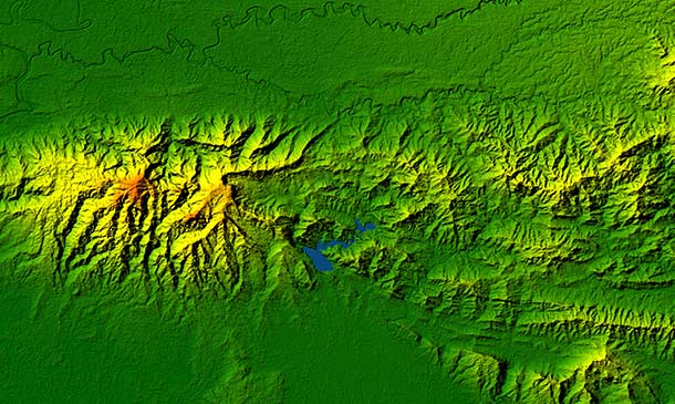
Basic Remote Sensing in ArcGIS
By Course Cloud
Arcgis is a leading geographic information system on the global market. In the Basic Remote Sensing in ArcGIS course, you will learn how to use the core tools for remote sensing in ArcGIS. It is designed in such a way that those with little to no experience in ArcGis can follow each module. Through this course, you will explore a wide range of tasks and learn how to perform them. You will be trained how to stack layers of imagery, master overlay analysis, georeference satellite images, and much more. This course is ideal for students of GIS, Geospatial Technicians and aspiring GIS specialists. It provides audio visual and instructor-led guidance for both part-time and full-time learners. This best selling Basic Remote Sensing in ArcGIS has been developed by industry professionals and has already been completed by hundreds of satisfied students. This in-depth Basic Remote Sensing in ArcGIS is suitable for anyone who wants to build their professional skill set and improve their expert knowledge. The Basic Remote Sensing in ArcGIS is CPD-accredited, so you can be confident you're completing a quality training course will boost your CV and enhance your career potential. The Basic Remote Sensing in ArcGIS is made up of several information-packed modules which break down each topic into bite-sized chunks to ensure you understand and retain everything you learn. After successfully completing the Basic Remote Sensing in ArcGIS, you will be awarded a certificate of completion as proof of your new skills. If you are looking to pursue a new career and want to build your professional skills to excel in your chosen field, the certificate of completion from the Basic Remote Sensing in ArcGIS will help you stand out from the crowd. You can also validate your certification on our website. We know that you are busy and that time is precious, so we have designed the Basic Remote Sensing in ArcGIS to be completed at your own pace, whether that's part-time or full-time. Get full course access upon registration and access the course materials from anywhere in the world, at any time, from any internet-enabled device. Our experienced tutors are here to support you through the entire learning process and answer any queries you may have via email.


Basic Spatial Analysis in ArcGIS
By Course Cloud
The Basic Spatial Analysis in ArcGIS course is ideal for anyone who works with spatial data and wants to gain full proficiency in ArcGis for faster, better spatial data analysis. It covers a wide range of topics such as slope maps and percentage, overlay analysis, raster reclassification, and 3D surfaces. Through this hands-on training course, you will learn in-demand skills to visualise and map spatial data for your own projects. It also explores theoretical concepts relating to spatial data analysis, broken down into easy to follow modules. This course is ideal for academics and researchers, conversation managers and field ecologists. Study on a part-time and full-time student and gain the practical skills and knowledge to gain a competitive edge in this field. This best selling Basic Spatial Analysis in ArcGIS has been developed by industry professionals and has already been completed by hundreds of satisfied students. This in-depth Basic Spatial Analysis in ArcGIS is suitable for anyone who wants to build their professional skill set and improve their expert knowledge. The Basic Spatial Analysis in ArcGIS is CPD-accredited, so you can be confident you're completing a quality training course will boost your CV and enhance your career potential. The Basic Spatial Analysis in ArcGIS is made up of several information-packed modules which break down each topic into bite-sized chunks to ensure you understand and retain everything you learn. After successfully completing the Basic Spatial Analysis in ArcGIS, you will be awarded a certificate of completion as proof of your new skills. If you are looking to pursue a new career and want to build your professional skills to excel in your chosen field, the certificate of completion from the Basic Spatial Analysis in ArcGIS will help you stand out from the crowd. You can also validate your certification on our website. We know that you are busy and that time is precious, so we have designed the Basic Spatial Analysis in ArcGIS to be completed at your own pace, whether that's part-time or full-time. Get full course access upon registration and access the course materials from anywhere in the world, at any time, from any internet-enabled device. Our experienced tutors are here to support you through the entire learning process and answer any queries you may have via email.


Master GIS: ArcGIS for Hydrology, Spatial Analysis, Remote Sensing & Cartography
(47)By Academy for Health and Fitness
***24 Hour Limited Time Flash Sale*** Master GIS: ArcGIS for Hydrology, Spatial Analysis, Remote Sensing & Cartography Admission Gifts FREE PDF & Hard Copy Certificate| PDF Transcripts| FREE Student ID| Assessment| Lifetime Access| Enrolment Letter Have you ever dreamed of turning your love for maps and data into a fulfilling career? The geospatial science field is booming in the UK, but a recent study by the Chartered Institute of Environmental Management revealed a shocking fact: 72% of environmental consultancies are struggling to find qualified professionals with the right GIS and data analysis skills. That's where our Master GIS program comes in! This Master GIS program provides in-depth training on ArcGIS, the industry-standard GIS software. You'll master essential skills like spatial analysis, remote sensing for data collection, and creating professional maps using both ArcGIS and open-source QGIS. Additionally, you'll gain expertise in Python programming, data visualisation, and web mapping, making you a highly sought-after geospatial professional. With this Master GIS: ArcGIS for Hydrology, Spatial Analysis, Remote Sensing & Cartography bundle, you will get 20 CPD Accredited PDF Certificates, Hard Copy Certificates, and our exclusive student ID card, all absolutely free. Courses Are Included In this Master GIS: ArcGIS for Hydrology, Spatial Analysis, Remote Sensing & Cartography Career Bundle: Course 01: Diploma in ArcGIS for Hydrology at QLS Level 4 Course 02: Award in Spatial Analysis in ArcGIS at QLS Level 2 Course 03: Remote Sensing in ArcGIS Course 04: QGIS Cartography Course 05: Business Intelligence and Data Mining Diploma Course 06: Python Data Science Course 07: Spatial Data Visualization and Machine Learning in Python Level 4 Course 08: Web Scraping and Mapping Dam Levels in Python and Leaflet Level 4 Course 09: Maps in R Shiny and Leaflet Course 10: Create Smart Maps in Python and Leaflet Level 3 Course 11: Advanced Diploma in Geology Course 12: Structural Geology, Tectonics & Rock Mechanics Course 13: Geospatial Technology, Remote Sensing and Web Mapping Course 14: Environmental Management Course 15: Environmental Law Course 16: Carbon Literacy Project Course 17: Forensic Anthropology Course 18: Autocad Design Course 19: Meteorology Course 20: Architectural Studies Invest in Your Future: Whether you're looking to launch a new career in GIS or enhance your existing skillset, this course bundle is your perfect starting point. Take your first step towards a rewarding career - enrol today! Learning Outcomes of Master GIS: ArcGIS for Hydrology Apply advanced ArcGIS techniques for hydrological analysis. Conduct spatial analysis to uncover hidden patterns in geospatial data. Utilise remote sensing imagery to extract valuable information. Create professional and informative maps using ArcGIS and QGIS. Analyse and visualise spatial data using Python libraries. Develop interactive web maps using Python and Leaflet. Why Choose Us? Get a Free CPD Accredited Certificate upon completion of Master GIS: ArcGIS for Hydrology Get a free student ID card with Master GIS: ArcGIS for Hydrology Training program (£10 postal charge will be applicable for international delivery) The Master GIS: ArcGIS for Hydrology is affordable and simple to understand This course is entirely online, interactive lesson with voiceover audio Get Lifetime access to the Master GIS: ArcGIS for Hydrology course materials The Master GIS: ArcGIS for Hydrology comes with 24/7 tutor support Take a step toward a brighter future! *** Course Curriculum *** Course 01: Diploma in ArcGIS for Hydrology at QLS Level 4 Section 01: Introduction To ArcGIS Software Introduction to ArcGIS software Selection by Location, attributes, clip features and tables to Excel Performing actions on the data: change the projections, dissolve, clip From .TXT and .DXF to shapefile Calculations with attribute table and KML files in ArcMap Export from ArcMap to PDF ArcScene 3D GIS Example Test AutoCAD fixing polygon coordinates Section 02: ArcGIS For Hydrology Download hydrological data Calculate flow direction and flow accumulation Watershed delineation Clip layers to watershed boundary Stream segments and catchments areas Stream order convert to vector Spatial join to catchments Join stream id to stream order Map data and initial layout Add and format map elements Course 02: Award in Spatial Analysis in ArcGIS at QLS Level 2 Module 01: Point Density Analysis Module 02: Raster Calculator and Vector Isolation Module 03: Raster to Topography Module 04: Raster Reclassification Module 05: Raster Overlay Module 06: Slope Analysis and Hydrology tools Module 07: Introduction to TIFF Files Module 08: Introduction to 3D Surfaces Module 09: Satellite Images and TIN Surfaces Module 10: Exercise Course 03: Remote Sensing in ArcGIS Module 01: Remote sensing, satellite images, spectral bands introduction Module 02: Layers stacking satellite images Module 03: Georeferencing satellite images Module 04: Introduction to geoprocessing raster tools Module 05: Raster Analysis Functions Module 06: Georeferencing toposheet Module 07: Site suitability using weighted overlay analysis - part 1 Module 08 Site suitability using weighted overlay analysis - part 2 Module 09: Watershed Delineation from DEM Module 10: Unsupervised classification =========>>>>> And 17 More Courses <<<<<========= How will I get my Certificate? After successfully completing the course, you will be able to order your Certificates as proof of your achievement. PDF Certificate: Free (Previously it was £12.99*20 = £259) CPD Hard Copy Certificate: Free ( For The First Course: Previously it was £29.99) QLS Endorsed Hard Copy Certificate: £79) CPD 200 CPD hours / points Accredited by CPD Quality Standards Who is this course for? Anyone interested in learning more about the topic is advised to take this bundle. This bundle is ideal for: GIS enthusiasts Environmental scientists Urban planners Data analysts Geographers Requirements You will not need any prior background or expertise to enrol in this course. Career path After completing this course, you are to start your career or begin the next phase of your career. GIS Analyst Cartographer Environmental Consultant Data Scientist Web Developer Planner Certificates CPD Accredited Digital Certificate Digital certificate - Included Upon passing the Course, you need to order a Digital Certificate for each of the courses inside this bundle as proof of your new skills that are accredited by CPD QS for Free. CPD Accredited Hard Copy Certificate Hard copy certificate - Included Please note that International students have to pay an additional £10 as a shipment fee. Award in Spatial Analysis in ArcGIS at QLS Level 2 Hard copy certificate - £79 Please note that International students have to pay an additional £10 as a shipment fee.

Embark on a transformative journey into the world of spatial analysis with our comprehensive Spatial Analysis in ArcGIS course. Master the art of extracting meaningful insights from geospatial data using the powerful ArcGIS platform. Delve into the intricacies of point density analysis, exploring techniques for identifying and analyzing patterns in point data distribution. Discover how to utilize raster calculator and vector isolation to manipulate and isolate raster and vector data for further analysis. Explore the concept of raster to topography conversion, learning how to transform raster data into elevation models and analyze terrain patterns. Uncover the secrets of raster reclassification, mastering techniques for reclassifying raster data to create thematic maps and enhance data visualization. Learning Outcomes Gain a comprehensive understanding of spatial analysis concepts and techniques Master the application of point density analysis to identify and interpret patterns in point data distribution Utilize raster calculator and vector isolation to manipulate and isolate raster and vector data for advanced analysis Perform raster to topography conversion to create elevation models and analyze terrain patterns Implement raster reclassification techniques to reclassify raster data, create thematic maps, and enhance data visualization Leverage ArcGIS tools to conduct spatial analysis effectively Apply spatial analysis techniques to solve real-world problems and make informed decisions Why choose this Spatial Analysis in ArcGIS course? Unlimited access to the course for a lifetime. Opportunity to earn a certificate accredited by the CPD Quality Standards and CIQ after completing this course. Structured lesson planning in line with industry standards. Immerse yourself in innovative and captivating course materials and activities. Assessments designed to evaluate advanced cognitive abilities and skill proficiency. Flexibility to complete the Course at your own pace, on your own schedule. Receive full tutor support throughout the week, from Monday to Friday, to enhance your learning experience. Unlock career resources for CV improvement, interview readiness, and job success. Who is this Spatial Analysis in ArcGIS course for? GIS professionals seeking to enhance their spatial analysis skills and knowledge Individuals interested in learning how to extract meaningful insights from geospatial data Urban planners, geographers, environmental scientists, and researchers working with spatial data Anyone seeking to advance their career in the field of GIS and spatial analysis Those seeking to utilize ArcGIS for spatial analysis and problem-solving Career path GIS Analyst (£25,000 - £45,000) GIS Specialist (£30,000 - £50,000) GIS Manager (£40,000 - £60,000) Senior GIS Analyst (£45,000 - £65,000) Spatial Data Scientist (£50,000 - £70,000) GIS Consultant (£50,000 - £70,000) Prerequisites This Spatial Analysis in ArcGIS does not require you to have any prior qualifications or experience. You can just enrol and start learning.This Spatial Analysis in ArcGIS was made by professionals and it is compatible with all PC's, Mac's, tablets and smartphones. You will be able to access the course from anywhere at any time as long as you have a good enough internet connection. Certification After studying the course materials, there will be a written assignment test which you can take at the end of the course. After successfully passing the test you will be able to claim the pdf certificate for £4.99 Original Hard Copy certificates need to be ordered at an additional cost of £8. Course Curriculum Module 01: Point Density Analysis Point Density Analysis 00:10:00 Module 02: Raster Calculator and Vector Isolation Raster Calculator and Vector Isolation 00:12:00 Module 03: Raster to Topography Raster to Topography 00:12:00 Module 04: Raster Reclassification Raster Reclassification 00:14:00 Module 05: Raster Overlay Raster Overlay 00:13:00 Module 06: Slope Analysis and Hydrology tools Raster Overlay 00:11:00 Module 07: Introduction to TIFF Files Raster Overlay 00:12:00 Module 08: Introduction to 3D Surfaces Introduction to 3D Surfaces 00:12:00 Module 09: Satellite Images and TIN Surfaces Satellite Images and TIN Surfaces 00:12:00 Module 10: Exercise Exercise 00:08:00 Assignment Assignment - Spatial Analysis in ArcGIS 00:00:00 Resources Resources - Spatial Analysis in ArcGIS 00:00:00
Overview Uplift Your Career & Skill Up to Your Dream Job - Learning Simplified From Home! Kickstart your career & boost your employability by helping you discover your skills, talents and interests with our special The Basics of ArcGIS for Hydrology Course. You'll create a pathway to your ideal job as this course is designed to uplift your career in the relevant industry. It provides professional training that employers are looking for in today's workplaces. The The Basics of ArcGIS for Hydrology Course is one of the most prestigious training offered at StudyHub and is highly valued by employers for good reason. This The Basics of ArcGIS for Hydrology Course has been designed by industry experts to provide our learners with the best learning experience possible to increase their understanding of their chosen field. This The Basics of ArcGIS for Hydrology Course, like every one of Study Hub's courses, is meticulously developed and well researched. Every one of the topics is divided into elementary modules, allowing our students to grasp each lesson quickly. At StudyHub, we don't just offer courses; we also provide a valuable teaching process. When you buy a course from StudyHub, you get unlimited Lifetime access with 24/7 dedicated tutor support. Why buy this The Basics of ArcGIS for Hydrology? Unlimited access to the course for forever Digital Certificate, Transcript, student ID all included in the price Absolutely no hidden fees Directly receive CPD accredited qualifications after course completion Receive one to one assistance on every weekday from professionals Immediately receive the PDF certificate after passing Receive the original copies of your certificate and transcript on the next working day Easily learn the skills and knowledge from the comfort of your home Certification After studying the course materials of the The Basics of ArcGIS for Hydrology there will be a written assignment test which you can take either during or at the end of the course. After successfully passing the test you will be able to claim the pdf certificate for £5.99. Original Hard Copy certificates need to be ordered at an additional cost of £9.60. Who is this course for? This The Basics of ArcGIS for Hydrology course is ideal for Students Recent graduates Job Seekers Anyone interested in this topic People already working in the relevant fields and want to polish their knowledge and skill. Prerequisites This The Basics of ArcGIS for Hydrology does not require you to have any prior qualifications or experience. You can just enrol and start learning.This The Basics of ArcGIS for Hydrology was made by professionals and it is compatible with all PC's, Mac's, tablets and smartphones. You will be able to access the course from anywhere at any time as long as you have a good enough internet connection. Career path As this course comes with multiple courses included as bonus, you will be able to pursue multiple occupations. This The Basics of ArcGIS for Hydrology is a great way for you to gain multiple skills from the comfort of your home. Course Curriculum Section 01: Introduction to ArcGIS software Introduction to ArcGIS software 00:09:00 Selection by Location, attributes, clip features and tables to Excel 00:11:00 Performing actions on the data: change the projections, dissolve, clip 00:13:00 From .TXT and .DXF to shapefile 00:10:00 Calculations with attribute table and KML files in ArcMap 00:11:00 Export from ArcMap to PDF 00:11:00 ArcScene 3D 00:08:00 GIS Example Test 00:15:00 AutoCAD fixing polygon coordinates 00:14:00 Section 02: ArcGIS for Hydrology Download hydrological data 00:06:00 Calculate flow direction and flow accumulation 00:09:00 Watershed delineation 00:10:00 Clip layers to watershed boundary 00:10:00 Stream segments and catchments areas 00:09:00 Stream order convert to vector 00:10:00 Spatial join to catchments 00:11:00 Join stream id to stream order 00:08:00 Map data and initial layout 00:11:00 Add and format map elements 00:14:00 Resources Resources - The Basics of ArcGIS for Hydrology 00:00:00 Assignment Assignment - The Basics of ArcGIS for Hydrology 00:00:00

Our Aim is Your Satisfaction! Offer Ends Soon; Hurry Up!! Are you looking to improve your current abilities or make a career move? Our unique GIS: Remote Sensing in ArcGIS Course might help you get there! Expand your expertise with high-quality training - study the course and get an expertly designed, great-value training experience. Learn from industry professionals and quickly equip yourself with the specific knowledge and skills you need to excel in your chosen career through the online training course. This Award in Remote Sensing in ArcGIS at QLS Level 2 course is endorsed by The Quality Licence Scheme and accredited by CPDQS (with 60 CPD points) to make your skill development & career progression more accessible than ever! Why Prefer This GIS : Remote Sensing in ArcGIS Course? Opportunity to earn certificate a certificate endorsed by the Quality Licence Scheme & another accredited by CPDQS after completing the GIS : Remote Sensing in ArcGIS course Get a free student ID card! (£10 postal charge will be applicable for international delivery) Innovative and engaging content. Free assessments 24/7 tutor support. Upon successful completion of the course, you will receive an instant e-certificate as proof of comprehensive skill development and competency. Add these amazing new skills to your resume and boost your employability by simply enroling in this course. You'll get a Free Student ID card by enroling in this course. This ID card entitles you to discounts on bus tickets, movie tickets, and library cards. Enroling in the course will ensure that you land your dream career faster than you thought possible. Stand out from the crowd and train for the job you want with the program. With this comprehensive GIS : Remote Sensing in ArcGIS course, you can achieve your dreams and train for your ideal career. The course provides students with an in-depth learning experience that they can work through at their own pace to enhance their professional development. Start your learning journey straight away with this course, and take a step toward a brighter future! ****Course Curriculum**** GIS : Remote Sensing in ArcGIS Course Module 01: Remote sensing, satellite images, spectral bands introduction Module 02: Layers stacking satellite images Module 03: Georeferencing satellite images Module 04: Introduction to geoprocessing raster tools Module 05: Raster Analysis Functions Module 06: Georeferencing toposheet Module 07: Site suitability using weighted overlay analysis - part 1 Module 08 Site suitability using weighted overlay analysis - part 2 Module 09: Watershed Delineation from DEM Module 10: Unsupervised classification Assessment Process After completing an online course module, you will be given immediate access to a specially designed MCQ test. The results will be immediately analysed, and the score will be shown for your review. The passing score for each test will be set at 60%. After passing the Award in Remote Sensing in ArcGIS at QLS Level 2exam, you will be able to request a certificate at an additional cost that has been endorsed by the Quality Licence Scheme. CPD 60 CPD hours / points Accredited by CPD Quality Standards Who is this course for? Is This Course Right for You? Anyone interested in learning more about this subject should take this course. This course will help you grasp the basic concepts as well as develop a thorough understanding of the subject. All are welcome to take this GIS : Remote Sensing in ArcGIS course. There are no prerequisites for enrolment, and you can access the course materials from any location in the world. Requirements The GIS : Remote Sensing in ArcGIS program does not require any prior knowledge; everyone may participate! This course is open to anyone interested in learning from anywhere in the world. Every student must be over the age of 16 and have a passion for learning and literacy. This 100% online course can be accessed from any internet-connected device, such as a computer, tablet, or smartphone. This course allows you to study at your speed and grow a quality skillset. Career path After completing this GIS : Remote Sensing in ArcGIS Course, you are to start your career or begin the next phase of your career in this field. Our entire course will help you to gain a position of respect and dignity over your competitors. The certificate enhances your CV and helps you find work in the field concerned. Certificates Certificate of completion Digital certificate - £10 Award in Remote Sensing in ArcGIS at QLS Level 2 Hard copy certificate - £79 Show off Your New Skills with a Certificate of Completion After successfully completing the Award in Remote Sensing in ArcGIS at QLS Level 2, you can order an original hardcopy certificate of achievement endorsed by the Quality Licence Scheme. The certificate will be home-delivered, with a pricing scheme of - 79 GBP inside the UK 89 GBP (including postal fees) for International Delivery Certificate Accredited by CPDQS 29 GBP for Printed Hardcopy Certificate inside the UK 39 GBP for Printed Hardcopy Certificate outside the UK (International Delivery)